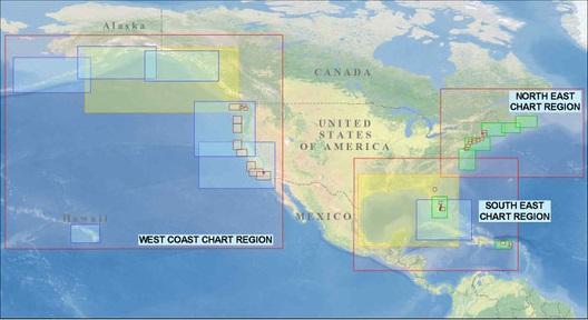

NASCA has revised the submarine telecommunications cable system routes of its members to further enhance the safety, protection, and continued operation of these critical assets. Submarine telecommunications cable systems have been designated as critical infrastructure due to their essential role in supporting both economic activity and national security.
NASCA Cable Charts provide interested stakeholders with a valuable resource for assessing the proximity of submarine cable systems to proposed coastal projects, infrastructure development, and other marine activities.
For submarine cable systems located within United States waters, cable routes are overlaid on NOAA nautical charts. For systems located outside U.S. waters, routes are displayed on the applicable equivalent nautical charts.
Viewers requiring additional detail regarding the location or routing of one or more submarine cable systems are encouraged to contact NASCA at CableCharts@n-a-s-c-a.org for further information.
* These charts only contain NASCA member systems. Users should be aware that the possibility exists that other non-plotted systems may be installed in a region of interest.
NASCA Cable Charts provide interested stakeholders with a valuable resource for assessing the proximity of submarine cable systems to proposed coastal projects, infrastructure development, and other marine activities.
For submarine cable systems located within United States waters, cable routes are overlaid on NOAA nautical charts. For systems located outside U.S. waters, routes are displayed on the applicable equivalent nautical charts.
Viewers requiring additional detail regarding the location or routing of one or more submarine cable systems are encouraged to contact NASCA at CableCharts@n-a-s-c-a.org for further information.
* These charts only contain NASCA member systems. Users should be aware that the possibility exists that other non-plotted systems may be installed in a region of interest.